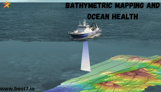
Bathymetric mapping (or seafloor mapping) is crucial to our understanding and management of ocean health. The map provides much-needed detail to help understand intricate seafloor habitats, aiding scientists in directing marine conservation, resource management, and climate change adaptation.
Acutely sensitive underwater sonar systems and state-of-the-art data acquisition efforts mean that scientists can monitor ocean health, track environmental impact assessments, and measure marine life vitality. In the future, bathymetric mapping will be even more critical to sustainable management of ocean resources and coastal zones.
Bathymetric Mapping—The Basis of Marine Conservation
Bathymetric mapping is an essential tool for conservation efforts, generating high-resolution images of the surface topography of the oceans that can provide valuable insight into the functions of marine systems. The structure of the seafloor helps scientists identify the different habitats that support marine biodiversity, from coral reefs and seagrass beds to deep-sea trenches.
By mapping the seafloor in such detail, conservationists can identify crucial but vulnerable habitats that require protection and then prioritize key areas where marine ecosystems remain intact, effectively conserving marine biodiversity.
Case Study: Great Barrier Reef Marine Park and Bathymetric Mapping
Bathymetric mapping for conservation is best illustrated by the case of Australia’s Great Barrier Reef Marine Park. Using sonar technology, researchers were able to scan many formations and discover how climate change and pollution were causing damage in already sensitive areas.
The maps allowed conservationists to devise better management techniques to preserve the reef’s biodiversity. Bathymetric mapping will be key to identifying and conserving at-risk habitats over the next few decades, especially as climate change-induced pressures ramp up.
Future Projection: Bathymetric Mapping in 2040 and Beyond
By 2040, bathymetric mapping could be available for up to 90% of the world’s coral reefs, enhancing biodiversity conservation for marine ecosystems. Improved mapping technology will provide support in the establishment of marine protected areas, targeting high biodiversity zones to protect crucial habitats for generations to come.
The Importance of Bathymetry to Resource Managers
Bathymetric Mapping: A Key Tool for Sustainable Resource Management
If we want to manage resources sustainably, having a deep understanding of benthic and diving ecosystems is essential. Managers use this information to assess economic benefits against environmental factors.
Bathymetric maps show the depth of ocean floor features, highlighting active zones in terms of fisheries, oil, and gas exploration, and identifying areas to avoid building due to sensitive habitats like seagrass beds.
Norway’s Sustainable Fisheries: A Practical Application of Bathymetric Mapping
A prime case for bathymetric mapping in resource management is seen in Norway, where highly detailed seafloor maps informed sustainable fishing policies. By mapping with sonar where fish lived and gathered to breed, researchers identified areas to restrict from fishing.
In Norway, implementing bathymetric maps in fisheries management increased fish population health by over 30% within protected areas. As resource demands increase in the future, extensive bathymetric mapping for sustainable ocean resource management will be essential.
Future Trends in Bathymetric Mapping for Fisheries Management
Within the next 15 years, bathymetric mapping applications in fisheries are expected to climb by 50%, promoting sustainable yields and marine ecosystem protection. Real-time 4D seafloor data from sensitive areas can further support these goals by facilitating the balance between economic growth and ocean health.
Climate Change Impact and Ecosystem Monitoring with Bathymetric Mapping
Tracking Climate Change with Bathymetric Maps
Bathymetric mapping provides invaluable ocean data to better understand the effects of climate change on marine ecosystems. With climate change accelerating, the health of our oceans faces pressures from warmer temperatures, higher acidity, and changing currents. Bathymetric maps allow scientists to track these changes over time, enabling evaluation of ecosystem sensitivity and predictions about future conditions.
The Arctic’s Disappearing Ice and the Role of Bathymetric Mapping
The melting Arctic ice highlights the urgency of mapping this rapidly changing seafloor. The decline of the Arctic ice cap has global climate implications and affects marine species in the region. Arctic bathymetric mapping contributes to climate adaptation strategies by guiding models that assess potential impacts of an ice-free northwest passage.
Future Outlook: Bathymetric Mapping for Climate Change Monitoring by 2050
By 2050, bathymetric mapping will enable the monitoring of 80% of the world’s oceans for biodiversity impacts and conservation management. This collective effort will support adaptive strategies to manage marine resources under changing climate conditions.
Advancements in Bathymetric Mapping Technology and Next-Generation Applications
Technological Innovations in Bathymetric Mapping
Recent advances in sonar technology and data capture techniques have broadened the applications of bathymetric mapping for oceanographic research and coastal management. With improved sonar resolution, underwater drones, and data analysis tools, scientists now capture high-quality seafloor images to assess ocean health and study marine biodiversity.
- Sonar Technology: Projected to increase resolution by 70% by 2030, enhancing the precision of underwater feature marking.
- Underwater Drones: Autonomous drones can improve mapping speed and coverage by over 60%, reducing costs and human input in data collection.
- Data Processing: Enhanced software can cut data analysis time by half, enabling real-time decision-making.
- Échelon Satellites: Improved seafloor data integration with environmental conditions, such as oceanic currents and sea surface temperatures.
- Interactive Mapping Systems: By 2040, enhanced 3D seafloor visualizations will enable researchers to explore the underwater landscape in detail.
- Ecosystem Modeling: Bathymetric data aids in ecosystem modeling to predict environmental changes and evaluate biodiversity risks.
The Future of Bathymetric Mapping Technology: 2045 and Beyond
By 2045, advancements in bathymetric mapping technology will enable 90% of the world’s seafloor to be monitored with unprecedented precision. This progress will not only deepen our understanding of unexplored areas but also strengthen efforts to protect ocean health through sustainable practices.


